- Accueil
- Découvrir et bouger
- Histoire et patrimoine
- Site archéologique de Petra Castellana
Le site archéologique de Petra Castellana
Les origines du site archéologique de Petra Castellana remontent au XIe ou XIIe siècle. Au Moyen Âge, c’est une ville fortifiée fondée par les Seigneurs de Castellane. La cité est progressivement abandonnée à partir de la fin du XIIIe siècle, les habitants préfèrent vivre dans le Bourg, actuel emplacement de Castellane. Remparts, tours, église, terrasses agricoles, tout est encore visible dans le site de Petra Castellana.
La Commune de Castellane a fait des travaux de stabilisation des vestiges (remparts, églises, murs de terrasses), d’aménagement d’un sentier d’interprétation et de valorisation du site archéologique de Petra Castellana, dans le cadre du programme européen TRA[ce]S – Transmettre la Recherche Archéologique dans les Alpes du Sud (financement ALCOTRA – INTERREG V – 2014-2020). Le projet a été réalisé avec l'architecte, Xavier Boutin. Le programme TRA[ce]S a aussi permis de réaliser 4 années de fouilles archéologiques menées par le Service Départemental d’Archéologie des Alpes de Haute Provence. Nous disposons donc de connaissances archéologiques, historiques et scientifiques sur le site de Petra Castellana, fief des Seigneurs de Castellane.
![]()
Accès au site de Petra Castellana par le sentier du Roc : 30 minutes depuis le centre ville
Durée du sentier d'interprétation dans le site : 30 minutes.
Uniquement piéton
Les itinéraires dans le site de Petra Castellana s’adressent à des randonneurs avertis, bien chaussés et correctement équipés, pouvant mesurer les dangers et circuler sur des sentiers escarpés. Pour votre sécurité restez sur les sentiers, ne franchissez pas les barrières métalliques ou végétales, ne montez pas sur les murs, surveillez vos enfants. En cas d’orage il est conseillé d’éviter de pénétrer sur le site (sols glissants, risque de foudre…).
Arrêté municipal n° 215/2019 : Selon le code du Patrimoine, articles L542-1, L544-1, L 535-1 et L535-15, l’usage de tout matériel permettant la détection d’objets métalliques […] pouvant intéresser la préhistoire, l’histoire, l’art ou l’archéologie, sans avoir, au préalable, obtenu une autorisation administrative est strictement interdit (amende de 7 500 euros).
Renseignements :
- Mairie de Castellane - Accueil Tél. : 04 92 83 60 07
- Maison Nature & Patrimoines - Accueil Tél. : 04 92 83 19 23
- Office de Tourisme de Castellane - Accueil Tél. : 04 92 72 59 12
Découvrez le site de Petra Castellana à travers la visite sonore réalisée par la troupe des Cabotins
MNP Castellane · Visite sonore de Petra Castellana
Découvrez le site de Petra Castellana avec la vidéo réalisée par le Département des Alpes de Haute-Provence, service Archéologie
"Petra Castellana" en français
"Petra Castellana" in english
"Petra Castellana" in italiano
L’église Saint-André du Roc
La construction de l’église Saint-André date de la fin du XIIe ou début du XIIIe siècle. C’était l’église paroissiale de Petra Castellana jusqu’en 1260. A cette date, la population est déjà plus nombreuse en bas dans le Bourg que perchée à Petra Castellana et demande que la paroisse soit transférée dans l’église Saint-Victor (située dans le centre ancien). L’église Saint-André est alors progressivement abandonnée.
L’église Saint-André est un édifice à nef unique et abside semi-circulaire. Sur la façade sud, face à vous, on peut encore voir les deux portails d’entrée, un grand et un plus petit, accompagnés de trois baies construites avec un arc en plein-cintre. Ces éléments sont comparables à ceux visibles sur la façade de l’église Saint-Victor. Sur la façade ouest, on remarque un oculus. Lors de la construction, une attention a été portée sur l’utilisation de pierres, calcaire et grès, de différentes couleurs. Aucun élément de toiture ne subsiste et l’église est très détériorée.
En 2019, des travaux sur l’église Saint-André ont permis de stabiliser l’extérieur de l’édifice. L’arcade de la porte est désormais soutenue par un ouvrage métallique ajusté. Les restes des façades sud et ouest ont été profondément confortés tant à l’intérieur même des murs qu’au niveau des tous les parements et sommets de murs. L’intérieur de l’édifice reste très dangereux et l’accès y est strictement interdit.
La cité de Petra Castellana et la chapelle Notre-Dame du Roc
Dans les archives, la première mention du nom Petra Castellana remonte à 977. C’est de ce nom que provient celui de l’une des plus puissantes familles aristocratiques de Provence, les Sires de Castellane. Leur château se trouvait au sommet du Roc mais en 1483, le roi Louis XI donne l’ordre de démanteler cette forteresse. Peu d’éléments ont été préservés, seules demeurent une citerne et la chapelle Notre-Dame du Roc, qui serait pour partie l’ancienne chapelle du château. Tout au long de l’histoire, la chapelle Notre-Dame du Roc a été détruite et reconstruite plusieurs fois. Les parties les plus anciennes seraient datées de la fin du XIIe et début du XIIIe siècle et les dernières transformations remontent au XIXe siècle. Plus d’informations sont disponibles directement à la chapelle.
En complément de leur forteresse, les seigneurs de Castellane ont construit la ville de Petra Castellana, en contrebas du Roc. C’est une agglomération fortifiée dont les origines remonteraient au XIe ou au XIIe siècle. Des tours massives et des remparts entouraient la ville jusqu’à la fin de XIIIe siècle. La cité a été progressivement abandonnée, les habitants préférant vivre dans le Bourg, actuel emplacement de Castellane. On voit encore quelques tours et une partie des remparts au nord et à l’est du site. Au sud, il ne reste quasiment plus de traces de la fortification. Des travaux de consolidation en 2019 ont stabilisé une partie des remparts.
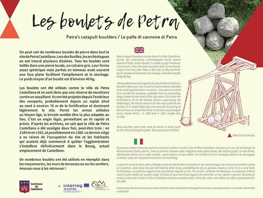
Les boulets de Petra
On peut voir de nombreux boulets de pierre dans tout le site de Petra Castellana. Lors des fouilles, les archéologues en ont trouvé plusieurs dizaines. Tous les boulets sont taillés dans une pierre locale, un calcaire gris. Leur forme assez sphérique mais parfois en tonneau avait souvent une face plane facilitant l’empilement et le stockage. Le poids moyen d’un boulet est d’environ 40 kg.
Les boulets ont été utilisés contre la ville de Petra Castellana et ne sont donc pas une réserve de munitions contre un assaillant. Ils ont été projetés depuis l’extérieur des remparts, probablement depuis un replat situé au nord à environ 70 m de la fortification et dominant légèrement le site. Parmi les armes utilisées au Moyen Âge, la bricole semble être la plus adaptée au lieu. C’est un engin léger, permettant un tir rapide et précis. D’après les archives, on sait que la ville de Petra Castellana a été assiégée deux fois, peut-être trois : en 1189 et en 1262, et possiblement en 1368. Le dernier siège a eu raison de l’occupation du site et les habitants qui avaient déjà commencé à quitter l’agglomération s’installent définitivement dans le Bourg, actuel emplacement de Castellane.
De nombreux boulets ont été utilisés en réemploi dans les maçonneries, les murs de terrasses ou sur les sentiers. Amusez-vous à les retrouver !
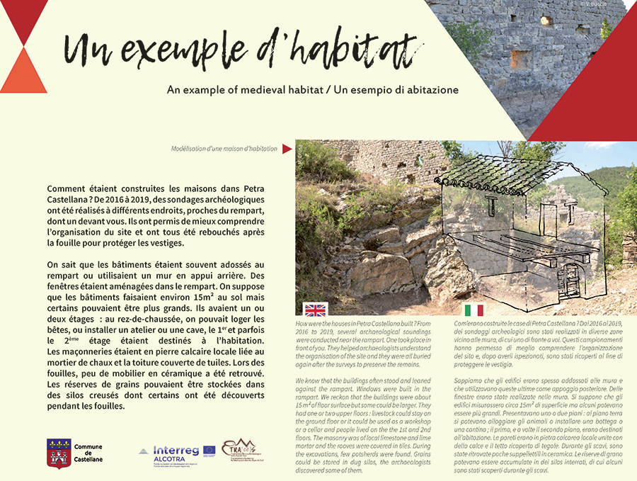
Un exemple d’habitat
Comment étaient construites les maisons dans Petra Castellana ? De 2016 à 2019, des sondages archéologiques ont été réalisés à différents endroits, proches du rempart, dont un devant vous. Ils ont permis de mieux comprendre l’organisation du site et ont tous été rebouchés après la fouille pour protéger les vestiges.
On sait que les bâtiments étaient souvent adossés au rempart, utilisant ce mur en appui arrière. Des fenêtres étaient aménagées dans le rempart. On suppose que les bâtiments faisaient environ 15m² au sol mais certains pouvaient être plus grands. Ils avaient un ou deux étages : au rez-de-chaussée, on pouvait loger les bêtes, ou installer un atelier ou une cave, le 1er et parfois le 2ème étage étaient destinés à l’habitation. Les maçonneries étaient en pierre calcaire locale liée au mortier de chaux et la toiture couverte de tuiles. Lors des fouilles, peu de mobilier en céramique a été retrouvé. Les réserves de grains pouvaient être stockées dans des silos creusés dont certains ont été découverts pendant les fouilles.
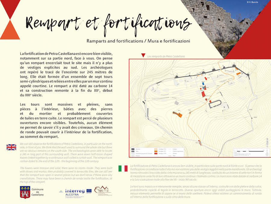
Rempart et fortification
La fortification de Petra Castellana est encore bien visible, notamment sur sa partie nord, face à vous. On pense que la fortification encerclait tout le site mais il n’y a plus de vestiges explicites au sud. Les archéologues ont repéré le tracé de l’enceinte sur 245 mètres de long qui était formé d’un ensemble de sept tours, en forme de demi-lune et reliées entre elles par un mur continu appelé courtine. Le rempart a été daté au carbone 14 et sa construction remonte à la fin du XIIe - début du XIIIe siècle.
Les tours sont massives et pleines, sans pièces à l’intérieur, bâties avec des pierres et du mortier et couvertes de tuiles en terre cuite. Le rempart est percé de plusieurs ouvertures encore visibles. Toutefois, aucun élément ne permet de savoir s’il y avait des créneaux. Un chemin de ronde pouvait courir à l’intérieur de la fortification, au sommet du rempart.
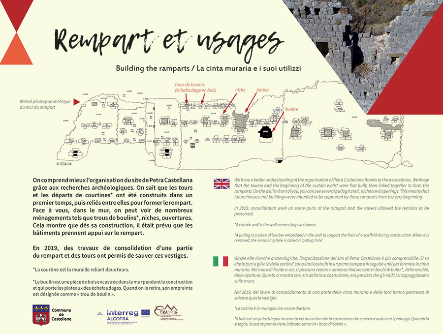
Rempart et ses usages
On comprend mieux l’organisation du site de Petra Castellana grâce aux recherches archéologiques. On sait que les tours et les départs de courtines* ont été construits dans un premier temps, puis reliées entre elles pour former le rempart. Face à vous, dans le mur, on peut voir de nombreux aménagements tels que trous de boulins*, niches, ouvertures. Cela montre que dès sa construction, il était prévu que les bâtiments prennent appui sur le rempart. En 2019, des travaux de consolidation d’une partie du rempart et des tours ont permis de sauver ces vestiges.
* La courtine est la muraille reliant deux tours.
* Le boulin est une pièce de bois encastrée dans le mur pendant la construction et qui porte les plateaux des échafaudages. Quand on le retire, son empreinte est désignée comme « trou de boulin ».
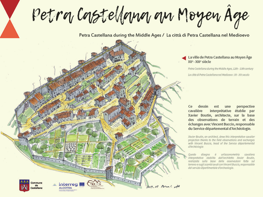
Petra Castellana au moyen âge
Ce dessin est une perspective cavalière interpretative établie par Xavier Boutin, architecte, sur la base des observations de terrain et des échanges avec Vincent Buccio, responsable du service départemental d'Archéologie.
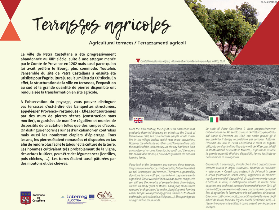
Terrasses agricoles
La ville de Petra Castellana a été progressivement abandonnée au XIIIe siècle, suite à une attaque menée par le Comte de Provence en 1262 mais aussi parce qu’on lui avait préféré le Bourg, plus commode. Toutefois l’ensemble du site de Petra Castellana a ensuite été utilisé pour l’agriculture jusqu’au milieu du XXe siècle. En effet, la structuration de la ville en terrasses, l’exposition au sud et la grande quantité de pierres disponible ont rendu aisée la transformation en site agricole.
En regardant le paysage, on voit que le site est organisé en terrasses c’est-à-dire en banquettes structurées, appelées en Provence « restanques ». Elles sont soutenues par des murs de pierres sèches (construction sans mortier), organisées de manière régulière et munies de dispositifs de circulation telles que des rampes d’accès. On distingue encore les ruines de cabanons en contrebas mais aussi les nombreux clapiers d’épierrage. Tous les ans, les pierres étaient extraites et amassées en tas afin de rendre plus facile le labour et la culture de la terre. Les hommes cultivaient très probablement de la vigne, des arbres fruitiers, peut-être des légumes secs (lentilles, pois chiches, …). Les terres étaient aussi pâturées par des moutons et des chèvres.
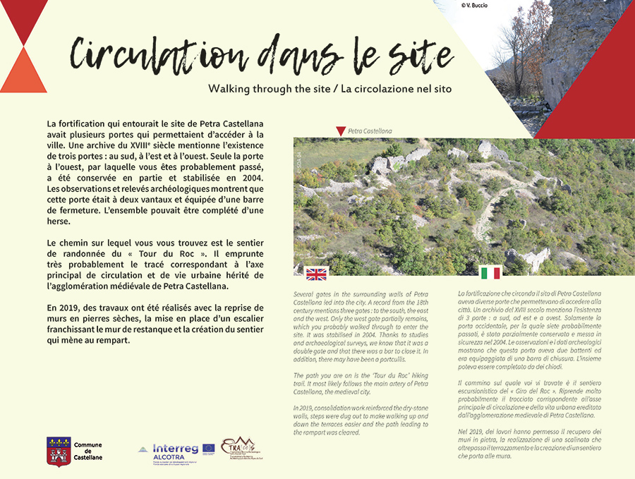
Circulation dans le site
La fortification qui entourait le site de Petra Castellana avait plusieurs portes qui permettaient d’accéder à la ville. Une archive du XVIIIe siècle mentionne l’existence de 3 portes : au sud, à l’est et à l’ouest. Seule la porte à l’ouest, par laquelle vous êtes probablement passés, a été conservée en partie et stabilisée en 2004. Les observations et relevés archéologiques montrent que cette porte était à deux vantaux et équipée d’une barre de fermeture. L’ensemble pouvait être complété d’une herse.
Le chemin sur lequel vous vous trouvez est le sentier de randonnée du « Tour du Roc ». Il emprunte très probablement le tracé correspondant à l’axe principal de circulation et de vie urbaine hérité de l’agglomération médiévale de Petra Castellana.
En 2019, des travaux ont été réalisés avec la reprise de murs en pierre sèche, la mise en place d’un escalier franchissant le mur de restanque et la création du sentier qui mène au rempart.
Petra Castellana au Moyen Âge
Ce dessin est une perspective cavalière interpretative établie par Xavier Boutin, architecte, sur la base des observations de terrain et des échanges avec Vincent Buccio, responsable du service départemental d'Archéologie.
The site of Petra Castellana
You are entering the site of Petra Castellana, which dates back to the 11th or 12th century. During the Middle Ages, it was a fortified city built by the Lords of Castellane. From the beginning of the 13th century, the city was gradually deserted because its inhabitants would rather live in the village bellow, where the heart of Castellane is currently located.
Ramparts, towers, agricultural terraces, a church and a castle! The interpretive trail offers a glimpse into life in Petra Castellana over the centuries.
Duration of visit : 30 minutes.
Please observe the guidelines and preserve the site.
The paths through the site of Petra Castellana are intended for well-informed ramblers wearing suitable hiking boots and able to assess the dangers of hiking on steep trails. For your own safety, don’t leave the trails, don’t cross metal or natural fences, don’t climb on the walls and watch your children at all times. During storm events, you are advised to avoid entering the site (slippery surfaces, risk of lightning…).
According to the Heritage Code, articles L542-1, L544-1, L 535-1 and L535-15, using any device to detect metal objects regarding the Prehistory, the History, art or archaeology without a preliminary administrative authorisation is strictly forbidden (7.500-euro fine).
The St André du Roc church
The St André church was built at the end of the 12th or the beginning of the 13th century. It was the parish church of Petra Castellana until 1260. At that time, there were already more people in the village bellow than in Petra Castellana and the inhabitants asked for the parish to be transferred to the St Victor church (located in the ancient centre). The St André church was then gradually abandoned.
The St André church had a single nave and a semi-circular apse. On the south wall in front of you, you can still see the two entrances, a large one and a smaller one, and three windows enclosed by a round arch. These features are similar to those on the front of the St Victor church. On the west wall, there still is an oculus. When the church was built, a particular attention was given to the use of stones of different colours (limestone and sandstone). No part of the roof remains and the church is very damaged.
In 2019, consolidation work on the St André church stabilised the exterior of the building. The arch of the door is now supported by a fitted metal structure. The remains of the south and west walls have been deeply reinforced inside the walls, on their surface and at their top. The inside of the church is very dangerous and it is strictly forbidden to enter it.
The city of Petra Castellana and the Notre-Dame-du-Roc chapel
In the records, the name Petra Castellana was first mentioned in 977. The place gave its name to one of the most powerful aristocratic families of Provence, the Lords of Castellane. Their castle was located at the top of the Roc but, in 1483, King Louis XI ordered the fortress to be destroyed. Few elements have been preserved, only a tank and Notre-Dame-du-Roc remain. The chapel is likely to have been built on the site of the former castle chapel. Over the course of history, the chapel has been destroyed and rebuilt several times. Its most ancient parts may date back to the end of the 12th and the beginning of the 13th century and the latest transformations date from the 19th century. More information are available at the chapel.
In addition to their fortress, the Lords of Castellane built the city of Petra Castellana below the Roc. It was a fortified city which dates back to the 11th or 12th century. Until the end of the 13th century, it was surrounded by massive towers and ramparts. The city was gradually deserted because its inhabitants would rather live in the village bellow, where the heart of Castellane is currently located. A few towers still remain, as well as parts of the ramparts east and north of the site. On the south, there are hardly any remnants of the fortification. In 2019, consolidation work stabilised a portion of the ramparts.
Petra’s catapult boulders
Many catapult boulders can be found in Petra Castellana. During the excavations, archaeologists found several dozens of them. Every boulder is made of grey limestone, a local stone. They are quite round but they can be barrel-shaped and they often have a flat side so they could be easily stacked and stocked. On average, a boulder weighs 40 kg (88 lbs).
The boulders were used against the city of Petra Castellana, therefore they were not a stock of ammunitions intended to be used against Petra’s ennemies. They were launched from outside the ramparts, probably from an overlooking ledge located to the north of the city, about 70 m from the fortifications. Of all the ballistic devices used during the Middle Ages, the bricole seems to be the most suited to the location. It is indeed light, fast and accurate. According to the archives, we know that Petra Castellana was besieged twice, maybe thrice : in 1189 and in 1262, maybe also in 1368. After the last siege, the city was abandoned for good and the inhabitants - who had already begun to leave - settled in the village bellow once and for all, where Castellane now stands. Many boulders were later used as stones to build walls on the site and along the paths. Try to spot some of them!
An example of medieval habitat
How were the houses in Petra Castellana built ? From 2016 to 2019, several archaeological soundings were conducted near the rampart. One took place in front of you. They helped archaeologists understand the organisation of the site and they were all buried again after the surveys to preserve the remains.
We know that the buildings often stood and leaned against the rampart. Windows were built in the rampart. We reckon that the buildings were about 15 m² of floor surface but some could be larger. They had one or two upper floors : livestock could stay on the ground floor or it could be used as a workshop or a cellar and people lived on the the 1st and 2nd floors. The masonry was of local limestone and lime mortar and the rooves were covered in tiles. During the excavations, few potsherds were found. Grains could be stored in dug silos, the archaeologists discovered some of them.
Ramparts and fortifications
We can still observe the fortifications of Petra Castellana, in particular on the north side, in front of you. We think that the wall used to surround the whole site but there are no obvious remains on the south side. The archaeologists were able to locate a 245 m long part of this surrounding wall. There were seven half-moon shaped towers linked together by a continuous wall called a curtain wall. The rampart was carbon dated to the end of the 12th - the beginning of the 13th century.
The towers were massive and solid, there were no rooms inside. They were built with stones and mortar, then covered in terracotta tiles. We can still see that the rampart was open in several places but we don’t know if there were any crenellations. There may have been a chemin de ronde inside the fortification, at the top of the rampart.
Building the ramparts
We have a better understanding of the organisation of Petra Castellana thanks to the excavations. We know that the towers and the beginning of the curtain walls* were first built, then linked together to form the ramparts. On the wall in front of you, you can see several putlog holes*, niches and openings. This means that future houses and buildings were intended to be supported by these ramparts from the very beginning. In 2019, consolidation work on some parts of the rampart and the towers allowed the remains to be preserved.
* A curtain wall is the wall connecting two towers.
* A putlog is a piece of lumber embedded in the wall to support the floor of a scaffold during construction. When it is removed, the remaining hole is called a ‘putlog hole’.
Petra Castellana during the Middle Ages
Xavier Boutin, an architect, drew this interpretative cavalier projection thanks to the field observations and exchanges with Vincent Buccio, head of the Service départemental d'Archéologie.
Agricultural terraces
From the 13th century, the city of Petra Castellana was gradually deserted following an attack by the Count of Provence in 1262, but also because people would rather live in the village bellow which was more convenient. However the whole site was then used for agriculture until the middle of the 20th century. As the city had been built on a system of terraces, it was facing south and there were lots of available stones, it proved easy to turn the site into farming lands.
If you look at the landscape, you can see these terraces. They are a series of successively receding flat surfaces that we call ‘restanques’ in Provence. They were supported by dry-stone terrace walls (no mortar) and they were evenly organised. There were facilities such as access ramps. We can still see the remains of several cabins down below, as well as many ‘clapiers’*. Each year, stones were removed and gathered to make ploughing and farming easier. Grapes were probably grown, as well as fruit trees and maybe pulses (lentils, chickpeas…). Sheep and goats also grazed on these lands.
* A ‘clapas’ (or ‘clapier’ in Provence) is a long pile made of stones that were removed from a piece of land about to be turned into a farming land.
Walking through the site
Several gates in the surrounding walls of Petra Castellana led into the city. A record from the 18th century mentions three gates : to the south, the east and the west. Only the west gate partially remains, which you probably walked through to enter the site. It was stabilised in 2004. Thanks to studies and archaeological surveys, we know that it was a double gate and that there were a bar to close it. In addition, there may have been a portcullis.
The path you are on is the ‘Tour du Roc’ hiking trail. It most likely follows the main artery of Petra Castellana, the medieval city. In 2019, consolidation work reinforced the dry-stone walls, steps were dug out to make walking up and down the terraces easier and the path leading to the rampart was cleared.
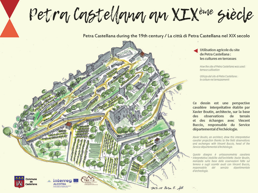
Petra Castellana during the 19th century
Xavier Boutin, an architect, drew this interpretative cavalier projection thanks to the field observations and exchanges with Vincent Buccio, head of the Service départemental d'Archéologie.
Sito di Petra Castellana
State per entrare nel sito di Petra Castellana le cui origini risalgono al XI o al XII secolo. Si tratta di una città fortificata fondata nel Medioevo dai Signori di Castellane. La città è progressivamente abbandonata a partire dalla fine del XIII secolo, quando gli abitanti preferiscono vivere nel Borgo, attuale villaggio di Castellane.
Le mura, le torri, la chiesa, il castello, i terrazzamenti agricoli ! Il sentiero di interpretazione vi da' un'idea della vita a Petra Castellana nel corso del tempo.
Durata del percorso : 30 minuti
Grazie di rispettare le indicazioni e contribuire così a preservare il sito.
Gli itinerari nel sito di Petra Castellana si rivolgono a degli escursionisti informati, con delle scarpe appropriate e un equipaggiamento corretto, in grado di valutare i pericoli e di circolare su dei sentieri scoscesi. Per la vostra sicurezza restate sui sentieri, non oltrepassate le barriere metalliche o vegetali, non salite sui muri, sorvegliate i vostri bambini. In caso di temporale è consigliato evitare di entrare nel sito (suoli scivolosi, rischio di fulmini…).
Secondo il codice del Patrimonio, articoli L542-1, L544-1, L 535-1 e L535-15, l’utilizzo di tutti i materiali in grado di individuare degli oggetti metallici […] suscettibili di avere un interesse per la preistoria, la storia, l’arte o l’archeologia, senza avere precedentemente ottenuto un'autorizzazione amministrativa, è strettamente vietato (multa di 7 500 euro).
La chiesa di Sant'Andrea del Roc
La costruzione della chiesa di Sant'Andrea risale tra la fine del XII e l'inizio del XIII secolo. Questa resterà la chiesa parrocchiale di Petra Castellana fino al 1260. A quest’epoca, la popolazione è più numerosa nella parte bassa del Borgo rispetto agli abitanti appollaiati a Petra Castellana e domanda che la parrocchia sia trasferita alla chiesa di San Vittore (situata nel cento storico). La chiesa di Sant'Andrea è allora progressivamente abbandonata.
La chiesa di Sant'Andrea è un edificio che presenta una sola navata e un abside semi-circolare. Sulla facciata meridionale, di fronte a voi, si possono ancora vedere i due portali d'entrata, uno grande e uno più piccolo, accompagnati da tre vetrate costruite con un arco a tutto sesto. Questi elementi sono comparabili a quelli visibili sulla facciata della chiesa di San Vittore. Sulla facciata occidentale, possiamo notare un oculus. Durante la costruzione, si è prestata attenzione alla scelta delle pietre, calcaree e arenarie, di differenti colori. Nessun elemento del tetto si è conservato e la chiesa si è molto deteriorata.
Nel 2019, dei lavori sulla chiesa di Sant'Andrea hanno permesso di mettere in sicurezza l'esterno dell'edificio. L’arcata della porta è ormai sostenuta da un'impalcatura metallica su misura. I resti delle facciate sud e ovest sono state profondamente consolidate sia all'interno stesso dei muri che a livello di tutti i paramenti e vertici delle pareti. L’interno dell'edificio resta molto pericoloso e l'accesso è severamente proibito.
La città di Petra Castellana e la cappella Notre-Dame du Roc
Negli archivi, la prima menzione del nome Petra Castellana risale al 977. È da questo nome che proviene quello di una delle più potenti famiglie aristocratiche della Provenza, i Signori di Castellane. Il loro castello si trovava sul promontorio del Roc ma nel 1483, il re Luigi XI da l'ordine di smantellare questa fortezza. Pochi elementi sono stati conservati, restano solamente una cisterna e la cappella Notre-Dame du Roc che corrisponderebbe in parte all’antica cappella del castello. Nel corso della storia, la cappella Notre-Dame du Roc è stata distrutta e ricostruita più volte. Le parti più antiche dovrebbero datare tra la fine del XII e l'inizio del XIII secolo mentre le ultime trasformazioni risalgono al XIX secolo. Delle informazioni più dettagliate sono disponibili direttamente alla cappella.
In aggiunta alla loro fortezza, i signori di Castellane hanno costruito, a ridosso del Roc, la città di Petra Castellana. Si tratta di un'agglomerazione fortificata le cui origini risalirebbero tra l’XI e il XII secolo. Delle torri massicce e delle mura difensive circondavano la città fino alla fine del XIII secolo. Visto che gli abitanti preferivano vivere nel Borgo, corrispondente all'attuale villaggio di Castellane, la città venne progressivamente abbandonata. Nella parte situata a nord e ad est del sito archeologico, si vedono ancora alcune torri e una parte delle mura. A sud, non resta praticamente più alcuna traccia della fortificazione. I lavori di consolidamento effettuati nel 2019 hanno stabilizzato una parte delle mura.
Le palle di cannone di Petra
Si possono vedere numerose palle di cannone in pietra in tutto il sito di Petra Castellana. Durante gli scavi, gli archeologi ne hanno trovate diverse decine. Tutte le palle di cannone sono intagliate nella pietra locale, del calcare grigio. La loro forma, abbastanza sferica ma a volte a botte, aveva spesso un lato piatto che facilitava la loro sovrapposizione e lo stoccaggio. In media, il peso di una palla di cannone è di circa 40 kg.
Le palle di cannone sono state utilizzate contro la città di Petra Castellana e non sono dunque una riserva di munizioni contro un assalitore. Sono state lanciate dall'esterno delle mura, probabilmente da un pianoro situato a circa 70 m a nord dalla fortificazione, in posizione leggermente soprelevata rispetto al sito. Tra le armi utilizzate nel Medioevo, la catapulta sembra essere la più adatta per questo luogo. Si tratta di una macchina leggera che permette un tiro rapido e preciso. Secondo gli archivi, si dice che la città di Petra Castellana sia stata assediata due, o forse tre, volte : nel 1189 e nel 1262, e probabilmente nel 1368. L'ultimo assedio si è terminato con l’occupazione del sito e gli abitanti, che avevano già cominciato a lasciare l'agglomerazione, si installano definitivamente nel Borgo, attuale villaggio di Castellane.
Numerose palle di cannone sono state utilizzate come materiale di riuso per le murature, i terrazzamenti o sui sentieri. Divertitevi a ritrovarli!
Un esempio di abitazione
Com'erano costruite le case di Petra Castellana ? Dal 2016 al 2019, dei sondaggi archeologici sono stati realizzati in diverse zone vicino alle mura, di cui uno di fronte a voi. Questi campionamenti hanno permesso di meglio comprendere l'organizzazione del sito e, dopo averli ispezionati, sono stati ricoperti al fine di proteggere le vestigia.
Sappiamo che gli edifici erano spesso addossati alle mura e che utilizzavano queste ultime come appoggio posteriore. Delle finestre erano state realizzate nelle mura. Si suppone che gli edifici misurassero circa 15m² di superficie ma alcuni potevano essere più grandi. Presentavano uno o due piani : al piano terra si potevano alloggiare gli animali o installare una bottega o una cantina ; il primo, e a volte il secondo piano, erano destinati all'abitazione. Le pareti erano in pietra calcarea locale unite con della calce e il tetto ricoperto di tegole. Durante gli scavi, sono state ritrovate poche suppellettili in ceramica. Le riserve di grano potevano essere accumulate in dei silos interrati, di cui alcuni sono stati scoperti durante gli scavi.
Mura e fortificazioni
La fortificazione di Petra Castellana è ancora ben visibile, in particolare sulla parte nord di fronte a voi. Si pensa che la fortificazione circondasse tutto il sito ma non esistono più delle vestigia leggibili nella parte meridionale. Gli archeologi hanno ritrovato il tracciato della cinta muraria su 245 metri di lunghezza, costituito da un insieme di sette torri in forma di mezzaluna unite fra di loro attraverso un muro continuo chiamato cortina. Le mura sono state datate al carbone 14 e la loro costruzione risale alla fine del XII – inizio XIII secolo.
Le torri sono massicce e interamente riempite, senza alcuna stanza all'interno, costruite con delle pietre e della calce, coperte di tegole in terracotta. Diverse aperture ancor oggi visibili punteggiano le mura. Tuttavia, nessun elemento permette di sapere se vi erano delle saettiere. Poteva altresì esistere un camminamento di ronda all'interno della fortificazione o sulla cima delle mura.
La cinta muraria e i suoi utilizzi
Grazie alle ricerche archeologiche, l'organizzazione del sito di Petra Castellana è più comprensibile. Si sa che le torri e gli inizi delle cortine* sono stati costruiti in un primo tempo e in seguito uniti per formare la cinta muraria. Nel muro di fronte a voi, si possono vedere numerose finiture come i buchi di bulini*, delle nicchie, delle aperture. Questo ci mostra che, sin dalla loro costruzione, era previsto che gli edifici si appoggiassero sulle mura. Nel 2019, dei lavori di consolidamento di una parte della cinta muraria e delle torri hanno permesso di salvare queste vestigia.
* La cortina è la muraglia che unisce due torri.
br> * Il bulino è un palo di legno incastrato nel muro durante la costruzione che serviva a sostenere i ponteggi. Quando lo si toglie, la sua impronta viene indicata come un « buco di bulino ».
La città di Petra Castellana nel Medioevo
Questo disegno è un'assonometria cavaliera interpretativa stabilita dall'architetto Xavier Boutin, realizzata salla base delle osservazioni fatte sul terreno e sugli scabi avuti con Vincent Buccio, responsabile del servizio dipartimentale d'archeologia.
Terrazzamenti agricoli
La città di Petra Castellana è stata progressivamente abbandonata nel XIII secolo a causa dell'attacco perpetrato dal Conte di Provenza nel 1262, ma anche perché gli si era preferito il Borgo, in posizione più comoda. Tuttavia, l'insieme del sito di Petra Castellana è stato in seguito utilizzato per l’agricoltura fino alla metà del XX secolo. Infatti la strutturazione della città in terrazze, l’esposizione a sud e la grande quantità di pietre disponibili, hanno facilitato la riconversione in sito agricolo.
Guardando il paesaggio, si vede che il sito è organizzato in terrazze ovvero in argini strutturati, chiamati in Provenza « restanques ». Questi sono sostenuti da dei muri in pietre a secco (costruzione senza calce), organizzati in maniera regolare e muniti di dispositivi di circolazione come le rampe d'accesso. A valle, si distinguono ancora le rovine delle capanne, ma anche dei numerosi ammassi di pietre. Tutti gli anni infatti, le pietre erano estratte e ammassate in cumuli al fine di agevolare la lavorazione e la coltivazione della terra. Gli uomini coltivavano molto probabilmente delle vigne, degli alberi da frutto, forse dei legumi secchi (lenticchie, ceci, …). I terreni erano anche utilizzati come pascoli per le pecore e le capre.
La circolazione nel sito
La fortificazione che circonda il sito di Petra Castellana aveva diverse porte che permettevano di accedere alla città. Un archivio del XVIII secolo menziona l’esistenza di 3 porte : a sud, ad est e a ovest. Solamente la porta occidentale, per la quale siete probabilmente passati, è stata parzialmente conservata e messa in sicurezza nel 2004. Le osservazioni e i dati archeologici mostrano che questa porta aveva due battenti ed era equipaggiata di una barra di chiusura. L’insieme poteva essere completato da dei chiodi.
Il cammino sul quale voi vi trovate è il sentiero escursionistico del « Giro del Roc ». Riprende molto probabilmente il tracciato corrispondente all'asse principale di circolazione e della vita urbana ereditato dall'agglomerazione medievale di Petra Castellana. Nel 2019, dei lavori hanno permesso il recupero dei muri in pietra, la realizzazione di una scalinata che oltrepassa il terrazzamento e la creazione di un sentiero che porta alle mura.
La città di Petra Castellana nel XIX secolo
Questo disegno è un'assonometria cavaliera interpretativa stabilita dall'architetto Xavier Boutin, realizzata salla base delle osservazioni fatte sul terreno e sugli scabi avuti con Vincent Buccio, responsabile del servizio dipartimentale d'archeologia.